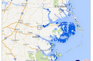
Expected flooding from storm surges pushed up by Hurricane Arthur in coastal North Carolina and parts of Virginia is seen in this experimental map from the National Hurricane Center. As I write this at 3:30 EDT, Hurricane Arthur's maximum sustained winds are pegged at 90 miles per hour, and conditions are already deteriorating along the North Carolina coast. The storm has accelerated and is intensifying, according to the National Hurricane Center. It is expected to reach Category 2 strength when it passes over or near the coast of North Carolina. That means winds of 95 to 100 miles per hour for the Cape Hatteras area at about 8 a.m. tomorrow. There is also a possibility that Arthur could strengthen to Category 3 status, but the odds are relatively small. No matter what, this hurricane poses very significant flooding risks for coastal areas, as the experimental map above from the National ...
Hurricane Arthur Threatens Serious Coastal Flooding
Hurricane Arthur poses serious flooding risks in North Carolina with storm surge predictions signaling dangerous conditions ahead.
More on Discover
Stay Curious
SubscribeTo The Magazine
Save up to 40% off the cover price when you subscribe to Discover magazine.
Subscribe

