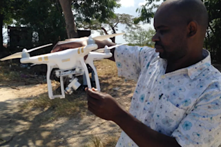
Makame Makame from the Zanzibar Malaria Elimination Programme holds one of the drones used to map malaria vectors. (Credit: Andy Hardy) On a typically hot and humid July day in Stonetown, the capital of Zanzibar, a gaggle of children, teenagers and the odd parents watched our small drone take flight. My colleagues Makame Makame, Khamis Haji and I had finally found the perfect launch spot. With a high-pitched humming, the drone took to the air. It sounded like a big mosquito—appropriate, since we were testing the use of drones for mapping aquatic malaria habitats. These shallow sunlit water bodies teem with mosquito larvae. In a matter of days, the larvae will emerge as adult mosquitoes in search of a blood meal. If one of those mosquitoes bites a human infected with malaria, it will become a vector for the disease and continue its deadly transmission cycle. Zanzibar is a Tanzanian ...
How Drones Are Being Used In Zanzibar's Fight Against Malaria
Discover how the Zanzibar Malaria Elimination Programme uses drone imagery for malaria vector mapping, enhancing larval source management.
More on Discover
Stay Curious
SubscribeTo The Magazine
Save up to 40% off the cover price when you subscribe to Discover magazine.
Subscribe


