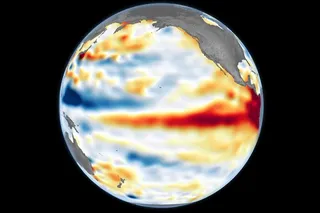


The 2026 El Niño is already smashing temperature records. The latest data from the Climate Change Institute show a daily anomaly of 3.11 degrees Celsius (5.60 degrees Fahrenheit) above baseline levels, eclipsing the record set in November 2015, which was — until earlier this month — the highest on record.
Tropical countries in the Global South are likely to be the worst impacted, but no part of the world will remain entirely untouched. The climate phenomenon triggers a temporary bump in global temperatures that disrupts weather patterns, causing high levels of rainfall and flooding in some parts of the world and drought elsewhere.
In North America, El Niño's effects also vary by location. Southern states typically experience wetter-than-normal conditions, whereas states in the northwest and around the Ohio Valley tend to experience drier winters. But, as the US Geological Survey (USGS) explains, even a so-called “Super El Niño” does not guarantee a particular weather pattern — rather, it tilts the scales in favor of certain conditions.
With that in mind, read on to find out what current predictions suggest an El Niño winter might look like in the U.S. and Canada.
Read More: Ancient Corals Reveal Today's El Niños Are the Strongest in 1,000 Years

 Explore All Options
Milder Winters in the Midwest
The Midwest — and northern states in general — can expect to experience a milder winter with above-average temperatures and fewer cold snaps. According to the USGS, previous strong El Niño events have seen temperatures climb 3 to 8 degrees Fahrenheit (or more) above the 20th-century average.
Floods and Storms in the South
The southern states are likely to feel the effects of the El Niño to a greater extent than their northern neighbors, with a higher chance of heavy rainfall and stormy weather.
Strong El Niño conditions typically push the jet stream south, which can bring cool conditions, high winds, and substantial precipitation. The latter can include rain, snow, sleet, and ice, and can result in extreme flooding. According to the USGS, ice storms are typically more frequent in eastern states like Louisiana, whereas blizzards are more common in the western states.
A Below Average Hurricane Season
While large parts of the country can expect heavy storms, there are likely to be fewer hurricanes than normal for residents in the contiguous U.S.
This is because El Niño events increase vertical wind shear (differences in wind direction or speed associated with a change in altitude). This suppresses hurricane formation by impeding a tropical storm’s ability to develop and strengthen.
The exception is Hawaii, where the opposite is true in the Pacific Ocean: El Niño typically breeds more storms and produces a more intense hurricane season.
Winter Storms in New England
There may be fewer hurricanes, but states in the northeast may be in for a wetter winter than usual as El Niño shifts the jet stream and the storms it brings further east.
According to the USGS, this could lead to more nor’easters, which can bring snow, rain, and large waves to coastal areas. This means the region may experience high levels of snowfall, even if temperatures tend towards above-average as a whole.
Severe Weather in California
According to the Scripps Institution of Oceanography, some of California’s wettest years on record have been Super El Niño events, including 1982 to 1983 and 1997 to 1998. An intense hurricane season in the Pacific can bring higher levels of rainfall to the southwest and areas including southern California.
In addition to heavy rain and strong winds, El Niño can increase the frequency of flooding, sea level rise, coastal erosion, and large waves.
Less Snowfall in Canada
Canada might see less snowfall this winter, with El Niño events typically associated with winters that are warmer and drier than average. According to Climate Data Canada, coastal areas face a higher likelihood of experiencing extreme storms and flooding, while more central areas are at higher risk of drought.
Read More: Brightening Clouds With Microscopic Sea Salt Particles Could Weaken Super El Niños in the Future
Article Sources
Our writers at Discovermagazine.com use peer-reviewed studies and high-quality sources for our articles, and our editors review for scientific accuracy and editorial standards. Review the sources used below for this article:
- This article references information from the Climate Change Institute at the University of Maine: Daily Sea Surface Temperature
- This article references information from the USGS: 2026 El Niño: What Does It Mean for Resource Managers?
- This article references information from the USGS: Regional Super El Niño Impacts: Alaska
- This article references information from the NOAA: How does El Niño Impact Atlantic Hurricane Season
- This article references information from the NOAA: Regional Super El Niño Impacts: South Central U.S.
- This article references information from the USGS: Regional Super El Niño Impacts: Northeast U.S.
- This article references information from the Scripps Institution of Oceanography: How Does El Niño Impact the Weather?
- This article references information from Climate Data Canada: What the developing exceptional El Niño means for Canada in 2026-27